
Digital Geography
The working group on Digital Geography explores the new means of Geographical Research in the Digital World.
Our works involves testing existing geographical theories and methods with new types of geodata. This data (e.g., geosocial media data, collective sensing data, PPGIS, etc.) is increasingly used in geographical studies. Their lack of semantic structure, varying and at times exuberant textual content may hide rich information that cannot be captured by traditional data sources. Also, we investigate new forms of analysis and modelling such as extending or adapting methods & workflows to become more spatially-aware. The fusion of new data and forms allows us to test new hypotheses (or triangulating them) on the relationships between humans and the environment.
Furthermore, we are interested in the new technologies that generate process, store, analyse and share data (smartphones, LBS, LBSN, mobile technical sensors, mobile apps, semi-volunteered online registrations/submissions) with the scope of evaluating and improving the geographical information that is being produced.
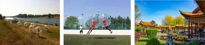
Geography Summer Event 2025
We are excited to announce our next Summer Event that takes place at Monday, June 30th, 2025.
We start our morning event with a fun game that fuses Bubbles with Soccer! We will play in small teams and short games to enhance team building and cooperation under unusual restrictive conditions. After our sport activity we can enjoy lunch together at one of the oldest traditional Chinese restaurants in Vienna.
The schedule is as follows:
- Start at 9:30 à Meeting point at the entrance of Sportcenter Donaucity, Arbeiterstrandbadstraße 128, 1220 Wien (next to Alte Donau subway station, line U1).
- 10:00 – 12:00 à Bubble Soccer games at a dedicated field in the sports complex (the facility offers cabinet rooms for your personal items).
- 12:30 -15:30 à Lunch at China Sichuan Restaurant, Arbeiterstrandbadstraße 122, 1220 Wien (we go by walk as it is next to the Sportcenter).
- End at 15:30 à End of our summer event. Those who are interested can continue with a relaxing walk at the beautiful Donaupark.